Loading page, please wait…
Vaidra Logo
Vaidra

Top 4 items + smart groups

UPSC GPT
New
Current Affairs
Daily Solutions
Daily Puzzle
Mains Evaluator

Version 2.0.0 • Built with ❤️ for UPSC aspirants

Loading...
Loading...
Loading...
Loading...
Loading...
Loading...
Loading...
Loading...
Loading...
Loading...
Loading...
Loading...
Loading...
Back
All Subjects

Topics

0 topics • 0 completed

Loading topics...
Loading...
Loading...
Loading...
Loading...
Loading...
Overall Progress0%

Major Port of India at Galathea Bay - UPSC Economy

What is Major Port of India at Galathea Bay in UPSC Economy?

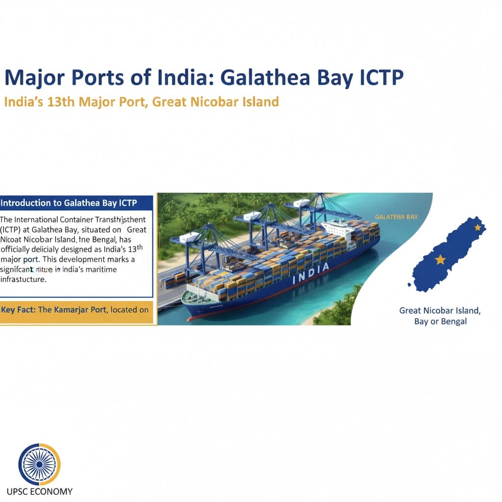
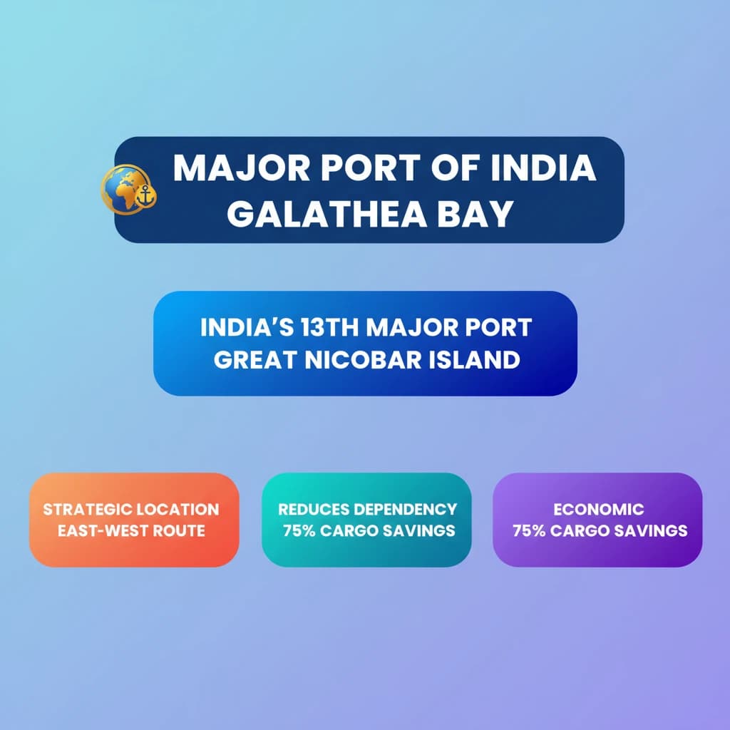
Major Port of India at Galathea Bay is a key topic under Economy for UPSC Civil Services Examination. Key points include: Galathea Bay (Great Nicobar Island) is India's 13th major port, following Kamarajar Port (12th).. The ICTP is strategically located near the East-West international shipping route and 40 nautical miles from the Malacca Strait.. It aims to reduce India's 75% dependency on foreign ports for transshipped cargo.. Understanding this topic is essential for both UPSC Prelims and Mains preparation.

Why is Major Port of India at Galathea Bay important for UPSC exam?

Major Port of India at Galathea Bay is a Medium-level topic in UPSC Economy. It is tested in both Prelims (factual MCQs) and Mains (analytical answer writing). Previous year UPSC questions have frequently covered aspects of Major Port of India at Galathea Bay, making it essential for comprehensive IAS preparation.

How to prepare Major Port of India at Galathea Bay for UPSC?

To prepare Major Port of India at Galathea Bay for UPSC: (1) Study the comprehensive notes covering all key concepts on Vaidra. (2) Practice previous year questions on this topic. (3) Connect it with current affairs using daily updates. (4) Revise using key takeaways and mind maps available for Economy. (5) Write practice answers linking Major Port of India at Galathea Bay to related GS Paper topics.

Key takeaways of Major Port of India at Galathea Bay for UPSC

  • Galathea Bay (Great Nicobar Island) is India's 13th major port, following Kamarajar Port (12th).
  • The ICTP is strategically located near the East-West international shipping route and 40 nautical miles from the Malacca Strait.
  • It aims to reduce India's 75% dependency on foreign ports for transshipped cargo.
  • Projected annual savings are USD 100-220 million in transshipment charges.
  • Great Nicobar is the southernmost and largest Nicobar Island, separated from Andamans by the 10° Channel.
  • The port enhances India's maritime economic sovereignty and supports the Act East Policy.
Major Port of India at Galathea Bay

Major Port of India at Galathea Bay

Medium⏱️ 8 min read✓ 95% Verified
economy

📖 Introduction

<h4>Introduction to Galathea Bay ICTP</h4><p>The <strong>International Container Transshipment Port (ICTP)</strong> at <strong>Galathea Bay</strong>, situated on <strong>Great Nicobar Island</strong> in the <strong>Bay of Bengal</strong>, has been officially designated as India's <strong>13th major port</strong>. This development marks a significant milestone in India's maritime infrastructure.</p><div class='info-box'><p><strong>Key Fact:</strong> The <strong>Kamarajar Port</strong>, located on the <strong>Coromandel Coast</strong> near <strong>Chennai</strong>, was previously designated as India's <strong>12th major port</strong>.</p></div><h4>Strategic Location of the ICTP</h4><p>The <strong>Galathea Bay ICTP</strong> boasts a highly strategic location. It lies directly along the vital <strong>East-West international trade and shipping route</strong>, which is one of the busiest maritime corridors globally.</p><p>Its proximity to established transshipment hubs like <strong>Singapore</strong>, <strong>Klang (Malaysia)</strong>, and <strong>Colombo (Sri Lanka)</strong> significantly enhances its importance within the global trade network. This positioning allows it to integrate seamlessly into existing shipping lanes.</p><div class='key-point-box'><p><strong>Crucial Proximity:</strong> The port is located just <strong>40 nautical miles</strong> from the <strong>Malacca Strait</strong>, a critical shipping route that handles approximately <strong>25% of global sea trade</strong>. This proximity positions it as a potential major transshipment hub.</p></div><p>The port holds strong potential to become a primary transshipment hub for cargo originating from India's <strong>east coast</strong>, as well as from neighboring countries like <strong>Bangladesh</strong> and <strong>Myanmar</strong>.</p><h4>Economic Advantages for India</h4><p>Currently, a substantial portion, nearly <strong>75%</strong>, of India's <strong>transshipped cargo</strong> is handled at foreign ports. The establishment of the <strong>Galathea Bay ICTP</strong> aims to significantly reduce this dependency on overseas facilities.</p><div class='info-box'><p><strong>Economic Benefit:</strong> By developing this domestic transshipment capacity, Indian ports could potentially save an estimated <strong>USD 100-220 million annually</strong> in transshipment charges that are currently paid to foreign ports.</p></div><h4>Context of Great Nicobar Island</h4><p><strong>Great Nicobar Island</strong> is the <strong>southernmost</strong> and <strong>largest</strong> island within the <strong>Nicobar Islands</strong> group. Its geographical features make it a suitable location for such a large-scale maritime project.</p><div class='info-box'><p><strong>Geographical Overview:</strong> The <strong>Andaman and Nicobar Islands</strong> comprise <strong>836 islands</strong> in total. They are broadly divided into two main groups: the <strong>northern Andaman Islands</strong> and the <strong>southern Nicobar Islands</strong>. These two groups are geographically separated by the <strong>10° Channel</strong>.</p></div><div class='exam-tip-box'><p><strong>UPSC Insight:</strong> Questions on infrastructure, strategic locations, and economic geography are common in <strong>GS-III (Economy & Infrastructure)</strong> and <strong>GS-I (Geography)</strong>. Understanding the strategic importance and economic rationale of projects like the <strong>Galathea Bay ICTP</strong> is vital.</p></div>
Concept Diagram

💡 Key Takeaways

  • •Galathea Bay (Great Nicobar Island) is India's 13th major port, following Kamarajar Port (12th).
  • •The ICTP is strategically located near the East-West international shipping route and 40 nautical miles from the Malacca Strait.
  • •It aims to reduce India's 75% dependency on foreign ports for transshipped cargo.
  • •Projected annual savings are USD 100-220 million in transshipment charges.
  • •Great Nicobar is the southernmost and largest Nicobar Island, separated from Andamans by the 10° Channel.
  • •The port enhances India's maritime economic sovereignty and supports the Act East Policy.

🧠 Memory Techniques

Memory Aid
95% Verified Content

Related Topics

Loading related topics...
Explore:Economy Topics·All Subjects·Daily Current Affairs·Editorial Analysis·Previous Year Questions·UPSC GPT
Major Port of India at Galathea Bay - UPSC Economy