Loading page, please wait…
Vaidra Logo
Vaidra

Top 4 items + smart groups

UPSC GPT
New
Current Affairs
Daily Solutions
Daily Puzzle
Mains Evaluator

Version 2.0.0 • Built with ❤️ for UPSC aspirants

Loading...
Loading...
Loading...
Loading...
Loading...
Loading...
Loading...
Loading...
Loading...
Loading...
Loading...
Loading...
Loading...
Back
All Subjects

Topics

0 topics • 0 completed

Loading topics...
Loading...
Loading...
Loading...
Loading...
Loading...
Overall Progress0%
Wildfires Triggering Pyrocumulonimbus Clouds - UPSC Geography

Wildfires Triggering Pyrocumulonimbus Clouds - UPSC Geography

What is Wildfires Triggering Pyrocumulonimbus Clouds in UPSC Geography?

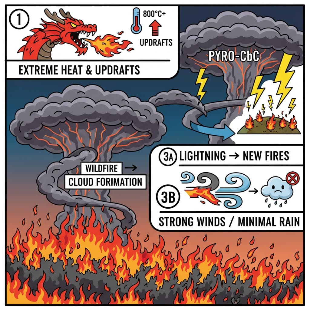
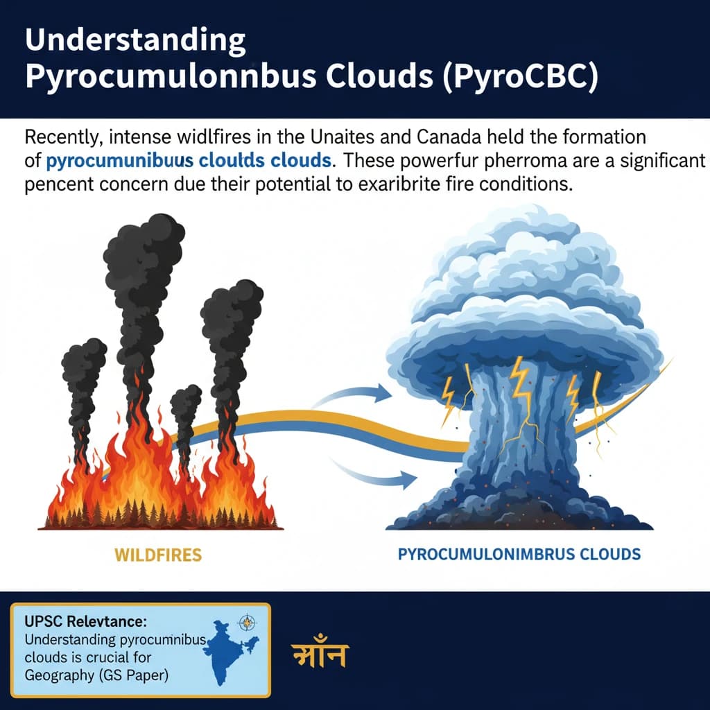
Wildfires Triggering Pyrocumulonimbus Clouds is a key topic under Geography for UPSC Civil Services Examination. Key points include: Pyrocumulonimbus clouds (PyroCbCs) are thunderclouds formed by intense heat from large wildfires or volcanic eruptions.. They require extreme heat (over 800°C) and strong updrafts of hot, smoke-laden air to form.. PyroCbCs can generate lightning, igniting new fires, and produce strong winds, accelerating fire spread.. Understanding this topic is essential for both UPSC Prelims and Mains preparation.

Why is Wildfires Triggering Pyrocumulonimbus Clouds important for UPSC exam?

Wildfires Triggering Pyrocumulonimbus Clouds is a Medium-level topic in UPSC Geography. It is tested in both Prelims (factual MCQs) and Mains (analytical answer writing). Previous year UPSC questions have frequently covered aspects of Wildfires Triggering Pyrocumulonimbus Clouds, making it essential for comprehensive IAS preparation.

How to prepare Wildfires Triggering Pyrocumulonimbus Clouds for UPSC?

To prepare Wildfires Triggering Pyrocumulonimbus Clouds for UPSC: (1) Study the comprehensive notes covering all key concepts on Vaidra. (2) Practice previous year questions on this topic. (3) Connect it with current affairs using daily updates. (4) Revise using key takeaways and mind maps available for Geography. (5) Write practice answers linking Wildfires Triggering Pyrocumulonimbus Clouds to related GS Paper topics.

Key takeaways of Wildfires Triggering Pyrocumulonimbus Clouds for UPSC

  • Pyrocumulonimbus clouds (PyroCbCs) are thunderclouds formed by intense heat from large wildfires or volcanic eruptions.
  • They require extreme heat (over 800°C) and strong updrafts of hot, smoke-laden air to form.
  • PyroCbCs can generate lightning, igniting new fires, and produce strong winds, accelerating fire spread.
  • Despite being thunderclouds, they typically produce minimal rain, hindering fire suppression.
  • Their increasing occurrence is linked to more intense wildfires, often exacerbated by climate change.
Wildfires Triggering Pyrocumulonimbus Clouds

Wildfires Triggering Pyrocumulonimbus Clouds

Medium⏱️ 8 min read✓ 95% Verified
geography

📖 Introduction

<h4>Understanding Pyrocumulonimbus Clouds (PyroCbCs)</h4><p>Recently, intense wildfires in the <strong>United States</strong> and <strong>Canada</strong> have led to the formation of <strong>pyrocumulonimbus clouds</strong>. These powerful weather phenomena are a significant concern due to their potential to exacerbate fire conditions.</p><div class='exam-tip-box'><p><strong>UPSC Relevance:</strong> Understanding <strong>pyrocumulonimbus clouds</strong> is crucial for <strong>Geography (GS Paper I)</strong>, especially under topics like climatology, atmospheric phenomena, and disaster management. It also connects to <strong>Environment (GS Paper III)</strong> regarding climate change impacts and wildfire management.</p></div><h4>What are Pyrocumulonimbus Clouds?</h4><div class='info-box'><p><strong>Definition:</strong> <strong>Pyrocumulonimbus clouds (PyroCbCs)</strong> are essentially <strong>thunder clouds</strong> that are generated by the intense heat emanating from the Earth's surface, primarily from large <strong>wildfires</strong> or <strong>volcanic eruptions</strong>. They are often referred to as <strong>fire clouds</strong>.</p></div><p>Their formation process is analogous to regular <strong>cumulonimbus clouds</strong>. However, the critical difference lies in the source of the vigorous updraft, which in this case, is the extreme heat from a fire event rather than conventional atmospheric instability.</p><h4>Conditions for PyroCbC Formation</h4><p>The development of <strong>pyrocumulonimbus clouds</strong> requires conditions of extreme heat. Not every wildfire will produce these clouds; specific temperature thresholds must be met for their initiation.</p><ul><li><strong>Extreme Heat:</strong> The primary trigger is an exceptionally hot source, such as a large-scale <strong>wildfire</strong> or a <strong>volcanic eruption</strong>.</li><li><strong>Temperature Threshold:</strong> Temperatures generally need to exceed <strong>800°C</strong> for these clouds to form. A notable instance was during the <strong>2019-2020 Australian bushfires</strong>, where such conditions were prevalent.</li><li><strong>Rapid Air Rise:</strong> The intense heat from the fire causes a rapid and powerful updraft of hot air. This rising air carries with it <strong>water vapour</strong>, <strong>smoke</strong>, and <strong>ash</strong>.</li><li><strong>Condensation and Cloud Growth:</strong> As this hot, smoke-laden air ascends and cools, the water vapour condenses around the smoke and ash particles, forming <strong>pyrocumulus clouds</strong>. If the updraft is strong enough, these can develop into full-fledged <strong>pyrocumulonimbus clouds</strong>.</li><li><strong>Altitude and Thunderstorm Systems:</strong> These clouds can reach significant altitudes, often up to <strong>50,000 feet</strong>. At these heights, they can evolve into self-sustaining <strong>thunderstorm systems</strong>, complete with <strong>lightning</strong> and strong, turbulent winds.</li></ul><h4>Impacts and Characteristics of PyroCbCs</h4><p>The formation of <strong>pyrocumulonimbus clouds</strong> has several critical impacts, primarily worsening wildfire conditions and complicating suppression efforts.</p><ul><li><strong>Lightning Ignition:</strong> A major concern is the production of <strong>lightning</strong> by these clouds. This lightning can strike several kilometres away from the original fire, igniting <strong>new wildfires</strong> and expanding the disaster zone.</li><li><strong>Minimal Rain Production:</strong> Despite being thunderclouds, <strong>pyrocumulonimbus clouds</strong> typically generate very little rain. The moisture is often evaporated before reaching the ground, meaning they aid in <strong>wildfire spread</strong> rather than suppression.</li><li><strong>Strong Winds:</strong> These clouds are associated with generating powerful and erratic winds. Such winds can significantly <strong>accelerate wildfire spread</strong>, making fire management extremely difficult and dangerous for firefighters.</li><li><strong>Smoke and Ash Dispersion:</strong> PyroCbCs are highly effective at lofting smoke and ash high into the atmosphere, which can then be transported over vast distances, impacting air quality far from the fire source.</li></ul>
Concept Diagram

💡 Key Takeaways

  • •Pyrocumulonimbus clouds (PyroCbCs) are thunderclouds formed by intense heat from large wildfires or volcanic eruptions.
  • •They require extreme heat (over 800°C) and strong updrafts of hot, smoke-laden air to form.
  • •PyroCbCs can generate lightning, igniting new fires, and produce strong winds, accelerating fire spread.
  • •Despite being thunderclouds, they typically produce minimal rain, hindering fire suppression.
  • •Their increasing occurrence is linked to more intense wildfires, often exacerbated by climate change.

🧠 Memory Techniques

Memory Aid
95% Verified Content

Related Topics

Loading related topics...
Explore:Geography Topics·All Subjects·Daily Current Affairs·Editorial Analysis·Previous Year Questions·UPSC GPT