Loading page, please wait…
Baselines: Defining Maritime Zones & Internal Waters - UPSC Geography
What is Baselines: Defining Maritime Zones & Internal Waters in UPSC Geography?
Baselines: Defining Maritime Zones & Internal Waters is a key topic under Geography for UPSC Civil Services Examination. Key points include: A Baseline is the reference line for measuring all maritime zones, typically the low-water mark.. Straight Baselines are used for deeply indented coastlines or islands close to shore.. Internal Waters are landward of the baseline; coastal states have full sovereignty with no innocent passage.. Understanding this topic is essential for both UPSC Prelims and Mains preparation.
Why is Baselines: Defining Maritime Zones & Internal Waters important for UPSC exam?
Baselines: Defining Maritime Zones & Internal Waters is a Medium-level topic in UPSC Geography. It is tested in both Prelims (factual MCQs) and Mains (analytical answer writing). Previous year UPSC questions have frequently covered aspects of Baselines: Defining Maritime Zones & Internal Waters, making it essential for comprehensive IAS preparation.
How to prepare Baselines: Defining Maritime Zones & Internal Waters for UPSC?
To prepare Baselines: Defining Maritime Zones & Internal Waters for UPSC: (1) Study the comprehensive notes covering all key concepts on Vaidra. (2) Practice previous year questions on this topic. (3) Connect it with current affairs using daily updates. (4) Revise using key takeaways and mind maps available for Geography. (5) Write practice answers linking Baselines: Defining Maritime Zones & Internal Waters to related GS Paper topics.
Key takeaways of Baselines: Defining Maritime Zones & Internal Waters for UPSC
- A Baseline is the reference line for measuring all maritime zones, typically the low-water mark.
- Straight Baselines are used for deeply indented coastlines or islands close to shore.
- Internal Waters are landward of the baseline; coastal states have full sovereignty with no innocent passage.
- Territorial Sea extends 12 nm from the baseline; coastal states have sovereignty but must allow innocent passage.
- Contiguous Zone extends 24 nm from the baseline; states can prevent/punish fiscal, immigration, sanitary, customs infringements.
- Exclusive Economic Zone (EEZ) extends 200 nm from the baseline; states have sovereign rights for resource exploration and exploitation.
- High Seas are beyond the EEZ, considered 'common heritage of all mankind' with freedom of navigation.
Baselines: Defining Maritime Zones & Internal Waters
Medium⏱️ 7 min read
geography
📖 Introduction
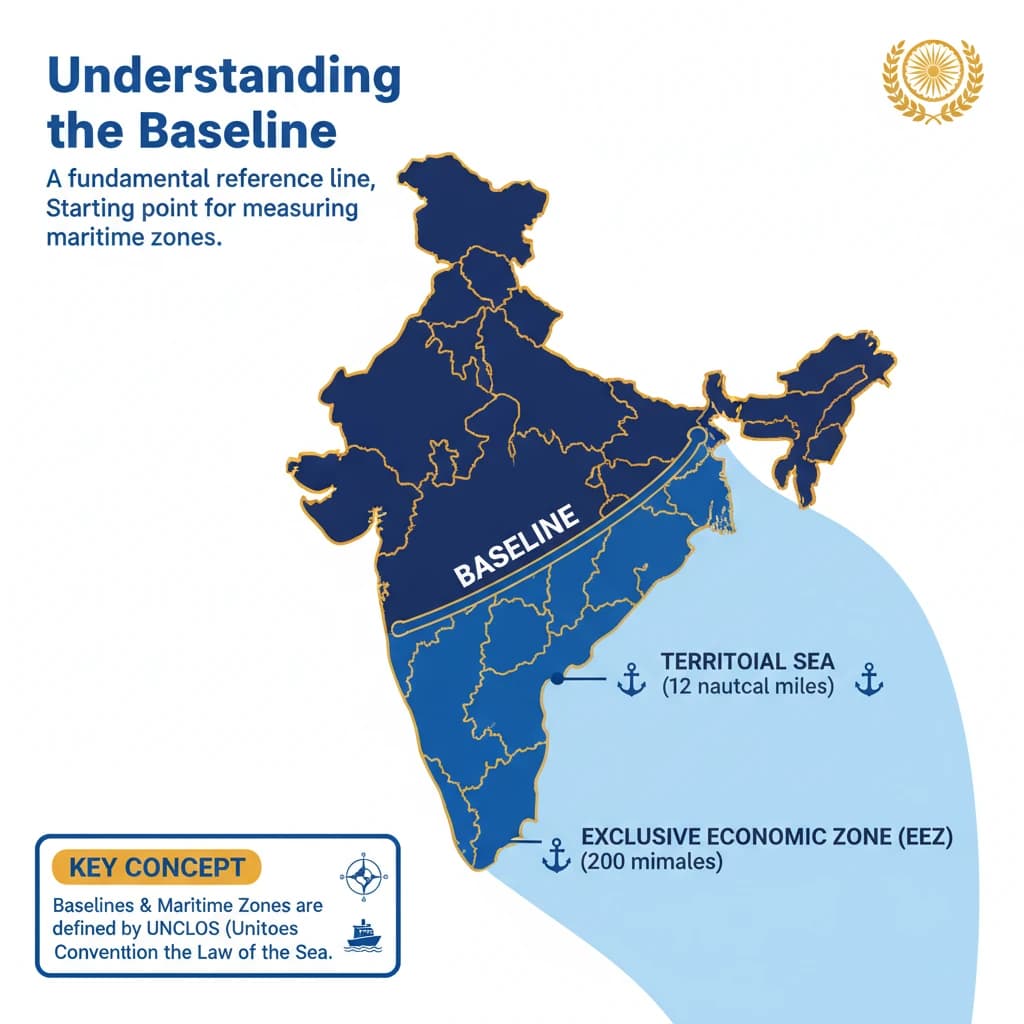
Understanding the Baseline
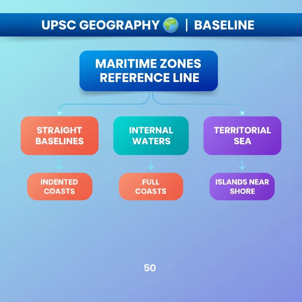
A baseline is a fundamental reference line, typically drawn along a nation's coastline. Its primary purpose is to serve as the starting point for measuring the outer limits of a state's various maritime zones, including its territorial sea and exclusive economic zone (EEZ).
The concept of baselines and maritime zones is primarily governed by the United Nations Convention on the Law of the Sea (UNCLOS), a landmark international treaty.
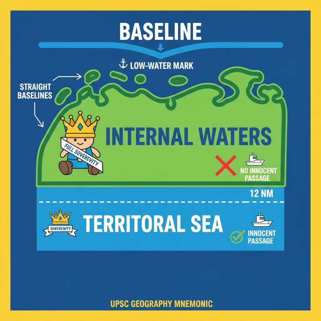
Normally, this baseline aligns with the low-water mark along the coast, representing the lowest tide level. This method is used for relatively smooth and stable coastlines.
Straight Baselines: Special Cases
In specific geographical situations, an alternative approach known as straight baselines may be adopted. This occurs when the coastline is highly indented, features numerous islands close to the shore, or exhibits significant instability due to geological factors.
Straight baselines connect selected points along the coast or outer islands, effectively enclosing areas that would otherwise be considered high seas, thereby creating internal waters.
Internal Waters: Full Sovereignty
Internal waters are defined as all waters situated on the landward side of the established baseline. These are the closest maritime areas to a state's land territory.
A coastal state exercises full sovereignty over its internal waters, akin to its land territory. This means it has complete control and jurisdiction over these areas.
Examples of internal waters include bays, ports, inlets, rivers, and even lakes that are connected to the sea. These areas are considered an integral part of the state.
A crucial aspect of internal waters is that there is no right to innocent passage through them. This means foreign vessels cannot pass through without the explicit permission of the coastal state.
Territorial Sea: Limited Sovereignty
The territorial sea extends seaward from the baselines up to a maximum distance of 12 nautical miles (nm). This zone is a direct extension of the state's sovereignty.
Within the territorial sea, coastal states possess sovereignty and jurisdiction. These rights encompass not only the water surface but also the seabed, subsoil, and the airspace above it.
However, the coastal state's rights in the territorial sea are subject to a significant limitation: the right to innocent passage. Foreign vessels are generally allowed to pass through, provided their passage is not prejudicial to the peace, good order, or security of the coastal state.
Contiguous Zone: Preventive Rights
The contiguous zone is an area adjacent to and extending beyond the territorial sea. It stretches seaward up to 24 nm from the baselines, creating an intermediary area between the territorial sea and the high seas.
In this zone, the coastal state has specific rights to prevent and punish infringement of its fiscal, immigration, sanitary, and customs laws. These laws must have been violated within its territory or territorial sea.
Unlike the territorial sea, the contiguous zone grants jurisdiction only over the ocean's surface and floor. It does not provide air and space rights to the coastal state.
Exclusive Economic Zone (EEZ): Resource Rights
Each coastal state has the right to claim an Exclusive Economic Zone (EEZ). This zone extends beyond and adjacent to its territorial sea, reaching up to 200 nm from its baselines.
Within its EEZ, a coastal state holds sovereign rights primarily for the purpose of exploring, exploiting, conserving, and managing natural resources. This includes both living and nonliving resources found in the seabed, subsoil, and overlying waters.
The EEZ also grants rights to engage in other economic activities, such as the production of energy from water, currents, and wind. This allows for renewable energy projects.
It is important to note that the EEZ primarily grants resource rights. Unlike the territorial sea and contiguous zone, it does not give a coastal state the right to prohibit or significantly limit freedom of navigation or overflight for other nations, with only limited exceptions.
Continental Shelf: Geological Extension
A continental shelf represents the natural geological extension of a continent beneath the ocean. It extends from the coastline out to a distinct drop-off point known as the shelf break.
Beyond the shelf break, the seafloor descends more steeply into the deep ocean basin, forming what is called the continental slope. This geological feature is distinct from the legal maritime zones, though related.
High Seas: Common Heritage
The areas of the ocean surface and the water column that lie beyond the outer limits of a state's EEZ are collectively referred to as the high seas. These vast areas are beyond any single national jurisdiction.
The high seas are considered the “common heritage of all mankind.” This principle implies that these areas should be used peacefully and for the benefit of all nations.
States are permitted to conduct various activities in the high seas, provided these activities are for peaceful purposes. This includes activities such as transit, marine science research, and undersea exploration, all subject to international law.
💡 Key Takeaways
- •A Baseline is the reference line for measuring all maritime zones, typically the low-water mark.
- •Straight Baselines are used for deeply indented coastlines or islands close to shore.
- •Internal Waters are landward of the baseline; coastal states have full sovereignty with no innocent passage.
- •Territorial Sea extends 12 nm from the baseline; coastal states have sovereignty but must allow innocent passage.
- •Contiguous Zone extends 24 nm from the baseline; states can prevent/punish fiscal, immigration, sanitary, customs infringements.
- •Exclusive Economic Zone (EEZ) extends 200 nm from the baseline; states have sovereign rights for resource exploration and exploitation.
- •High Seas are beyond the EEZ, considered 'common heritage of all mankind' with freedom of navigation.
🧠 Memory Techniques
98% Verified Content
📚 Reference Sources
•Drishti IAS Study Material on Maritime Zones
•Ministry of External Affairs, Government of India (Maritime Zones Act, 1976)
•International Court of Justice (ICJ) rulings on maritime delimitation