Loading page, please wait…
Vaidra Logo
Vaidra

Top 4 items + smart groups

UPSC GPT
New
Current Affairs
Daily Solutions
Daily Puzzle
Mains Evaluator

Version 2.0.0 • Built with ❤️ for UPSC aspirants

Loading...
Loading...
Loading...
Loading...
Loading...
Loading...
Loading...
Loading...
Loading...
Loading...
Loading...
Loading...
Loading...

How Earthquakes Impact the Course of a River Ganga? - UPSC Geography

What is How Earthquakes Impact the Course of a River Ganga? in UPSC Geography?

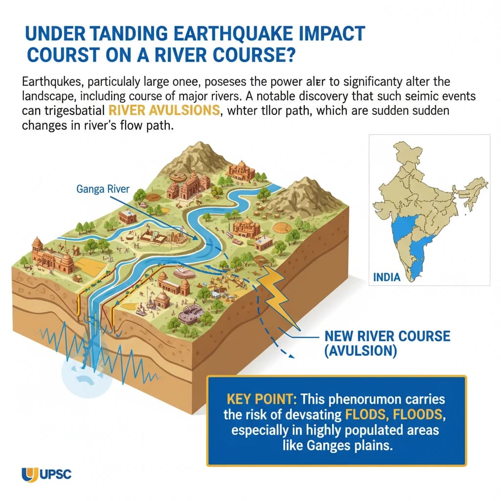
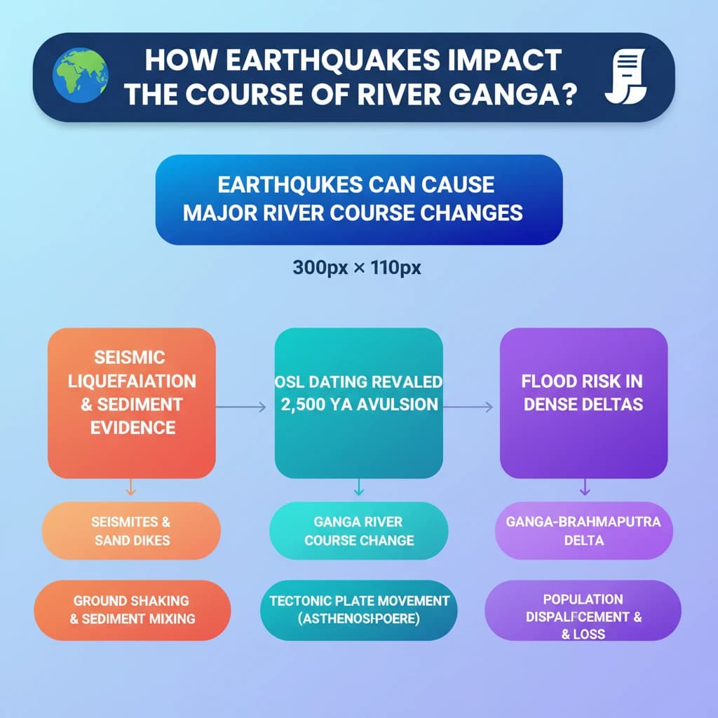
How Earthquakes Impact the Course of a River Ganga? is a key topic under Geography for UPSC Civil Services Examination. Key points include: Large earthquakes can cause significant river avulsions (course changes).. Evidence includes seismites and sand dikes, formed by seismic liquefaction.. OSL dating confirmed a Ganga River avulsion 2,500 years ago due to an earthquake.. Understanding this topic is essential for both UPSC Prelims and Mains preparation.

Why is How Earthquakes Impact the Course of a River Ganga? important for UPSC exam?

How Earthquakes Impact the Course of a River Ganga? is a Medium-level topic in UPSC Geography. It is tested in both Prelims (factual MCQs) and Mains (analytical answer writing). Previous year UPSC questions have frequently covered aspects of How Earthquakes Impact the Course of a River Ganga?, making it essential for comprehensive IAS preparation.

How to prepare How Earthquakes Impact the Course of a River Ganga? for UPSC?

To prepare How Earthquakes Impact the Course of a River Ganga? for UPSC: (1) Study the comprehensive notes covering all key concepts on Vaidra. (2) Practice previous year questions on this topic. (3) Connect it with current affairs using daily updates. (4) Revise using key takeaways and mind maps available for Geography. (5) Write practice answers linking How Earthquakes Impact the Course of a River Ganga? to related GS Paper topics.

Key takeaways of How Earthquakes Impact the Course of a River Ganga? for UPSC

  • Large earthquakes can cause significant river avulsions (course changes).
  • Evidence includes seismites and sand dikes, formed by seismic liquefaction.
  • OSL dating confirmed a Ganga River avulsion 2,500 years ago due to an earthquake.
  • Tectonic plates move due to convection currents in the asthenosphere, causing earthquakes.
  • River avulsions pose a major flood risk, especially in densely populated deltas like the Ganges-Meghna-Brahmaputra.
  • This highlights the critical need for integrating geological studies into disaster management and urban planning.
How Earthquakes Impact the Course of a River Ganga?

How Earthquakes Impact the Course of a River Ganga?

Medium⏱️ 6 min read✓ 95% Verified
geography

📖 Introduction

<h4>Understanding Earthquake Impact on River Courses</h4><p>Earthquakes, particularly large ones, possess the power to significantly alter the landscape, including the course of major rivers. A notable discovery highlights that such seismic events can trigger substantial <strong>river avulsions</strong>, which are sudden changes in a river's flow path.</p><div class='key-point-box'><p>This phenomenon carries the risk of devastating <strong>floods</strong>, especially in highly populated areas like the <strong>Ganges-Meghna-Brahmaputra delta</strong>, where millions reside.</p></div><h4>Evidence of Earthquake-Induced River Avulsion</h4><p>Researchers have uncovered compelling geological evidence indicating that earthquakes can indeed cause river avulsions. This evidence primarily consists of specific sedimentary formations and dating techniques.</p><h5>Seismite Formation</h5><p><strong>Seismites</strong> are distinctive sedimentary beds that have been deformed by seismic movements. Their formation is a direct indicator of past earthquake activity.</p><div class='info-box'><p><strong>Definition:</strong> <strong>Seismites</strong> are formed when seismic waves pressurize a layer of watery sand, causing it to burst through overlying mud layers, creating characteristic deformation patterns within the sediment.</p></div><h5>Sand Dikes</h5><p>Another crucial piece of evidence found by researchers near a palaeochannel (an ancient river course) were large <strong>sand dikes</strong>.</p><div class='info-box'><p><strong>Definition:</strong> <strong>Sand Dikes</strong> are formed when earthquakes disturb the riverbed, leading to the liquefaction of sediments. This process causes sand and water to be injected upwards through overlying layers, forming dike-like structures.</p></div><h5>Dating Techniques: Optically Stimulated Luminescence (OSL)</h5><p>To establish a timeline for these geological events, researchers employed <strong>Optically Stimulated Luminescence (OSL) dating</strong>. This technique allows scientists to determine when sediment was last exposed to sunlight.</p><div class='info-box'><p><strong>OSL Dating Results:</strong> Using <strong>OSL dating</strong>, it was determined that both the river avulsion and the formation of the associated <strong>sand dikes</strong> occurred approximately <strong>2,500 years ago</strong>. This temporal correlation strongly suggests that an earthquake was the causative factor for the river's change in course.</p></div><h4>What are Tectonic Activities?</h4><p>The underlying mechanism for earthquakes and many geological changes is <strong>tectonic activity</strong>. This refers to the dynamic processes occurring within the Earth's lithosphere.</p><div class='info-box'><p>The Earth’s outermost layer, known as the <strong>lithosphere</strong>, is composed of the <strong>crust</strong> and the <strong>upper mantle</strong>. This rigid layer is not a single, continuous shell but is broken into several large, rocky fragments called <strong>tectonic plates</strong>.</p></div><p>These <strong>tectonic plates</strong> do not remain static. They rest upon a partially molten, ductile layer beneath the lithosphere, called the <strong>asthenosphere</strong>.</p><p>The movement of these plates is driven by <strong>convection currents</strong> within the <strong>asthenosphere</strong>. These currents cause the plates to move at varying rates, typically between <strong>2 to 15 centimeters per year</strong>, leading to geological phenomena like earthquakes, volcanic activity, and mountain building.</p>
Concept Diagram

💡 Key Takeaways

  • •Large earthquakes can cause significant river avulsions (course changes).
  • •Evidence includes seismites and sand dikes, formed by seismic liquefaction.
  • •OSL dating confirmed a Ganga River avulsion 2,500 years ago due to an earthquake.
  • •Tectonic plates move due to convection currents in the asthenosphere, causing earthquakes.
  • •River avulsions pose a major flood risk, especially in densely populated deltas like the Ganges-Meghna-Brahmaputra.
  • •This highlights the critical need for integrating geological studies into disaster management and urban planning.

🧠 Memory Techniques

Memory Aid
95% Verified Content

Related Topics

Loading related topics...
Explore:Geography Topics·All Subjects·Daily Current Affairs·Editorial Analysis·Previous Year Questions·UPSC GPT
Back
All Subjects

Topics

0 topics • 0 completed

Loading topics...
Loading...
Loading...
Loading...
Loading...
Loading...
Overall Progress0%
How Earthquakes Impact the Course of a River Ganga? - UPSC Geography