Loading page, please wait…
How La Nina and El Nino are Predicted? - UPSC Geography
What is How La Nina and El Nino are Predicted? in UPSC Geography?
How La Nina and El Nino are Predicted? is a key topic under Geography for UPSC Civil Services Examination. Key points include: ENSO prediction uses climate models and observational data (SST, trade winds, satellites, buoys).. Oceanic Nino Index (ONI) defines El Nino/La Nina based on 3-month average SST anomalies in East-Central Tropical Pacific (Nino 3.4 region).. ONI thresholds: +0.5°C for El Nino, -0.5°C for La Nina (for 5 consecutive periods).. Understanding this topic is essential for both UPSC Prelims and Mains preparation.
Why is How La Nina and El Nino are Predicted? important for UPSC exam?
How La Nina and El Nino are Predicted? is a Medium-level topic in UPSC Geography. It is tested in both Prelims (factual MCQs) and Mains (analytical answer writing). Previous year UPSC questions have frequently covered aspects of How La Nina and El Nino are Predicted?, making it essential for comprehensive IAS preparation.
How to prepare How La Nina and El Nino are Predicted? for UPSC?
To prepare How La Nina and El Nino are Predicted? for UPSC: (1) Study the comprehensive notes covering all key concepts on Vaidra. (2) Practice previous year questions on this topic. (3) Connect it with current affairs using daily updates. (4) Revise using key takeaways and mind maps available for Geography. (5) Write practice answers linking How La Nina and El Nino are Predicted? to related GS Paper topics.
Key takeaways of How La Nina and El Nino are Predicted? for UPSC
- ENSO prediction uses climate models and observational data (SST, trade winds, satellites, buoys).
- Oceanic Nino Index (ONI) defines El Nino/La Nina based on 3-month average SST anomalies in East-Central Tropical Pacific (Nino 3.4 region).
- ONI thresholds: +0.5°C for El Nino, -0.5°C for La Nina (for 5 consecutive periods).
- Nino-3.4 Index identifies event initiation (0.5°C anomaly) and strength (1.5°C+ for strong El Nino).
- La Nina following strong El Nino can be predicted up to two years in advance.
- Accurate ENSO predictions are vital for agriculture, water management, and disaster preparedness globally.
How La Nina and El Nino are Predicted?
Medium⏱️ 8 min read
geography
📖 Introduction
Understanding ENSO Prediction
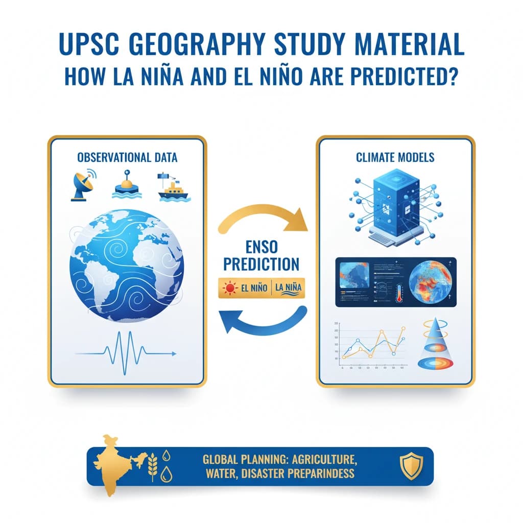
Scientists employ a combination of climate models and extensive observational data to forecast the onset and intensity of ENSO events, which include both El Nino and La Nina.
Accurate predictions are crucial for global planning, especially in sectors like agriculture, water management, and disaster preparedness, given the widespread climatic impacts of these phenomena.
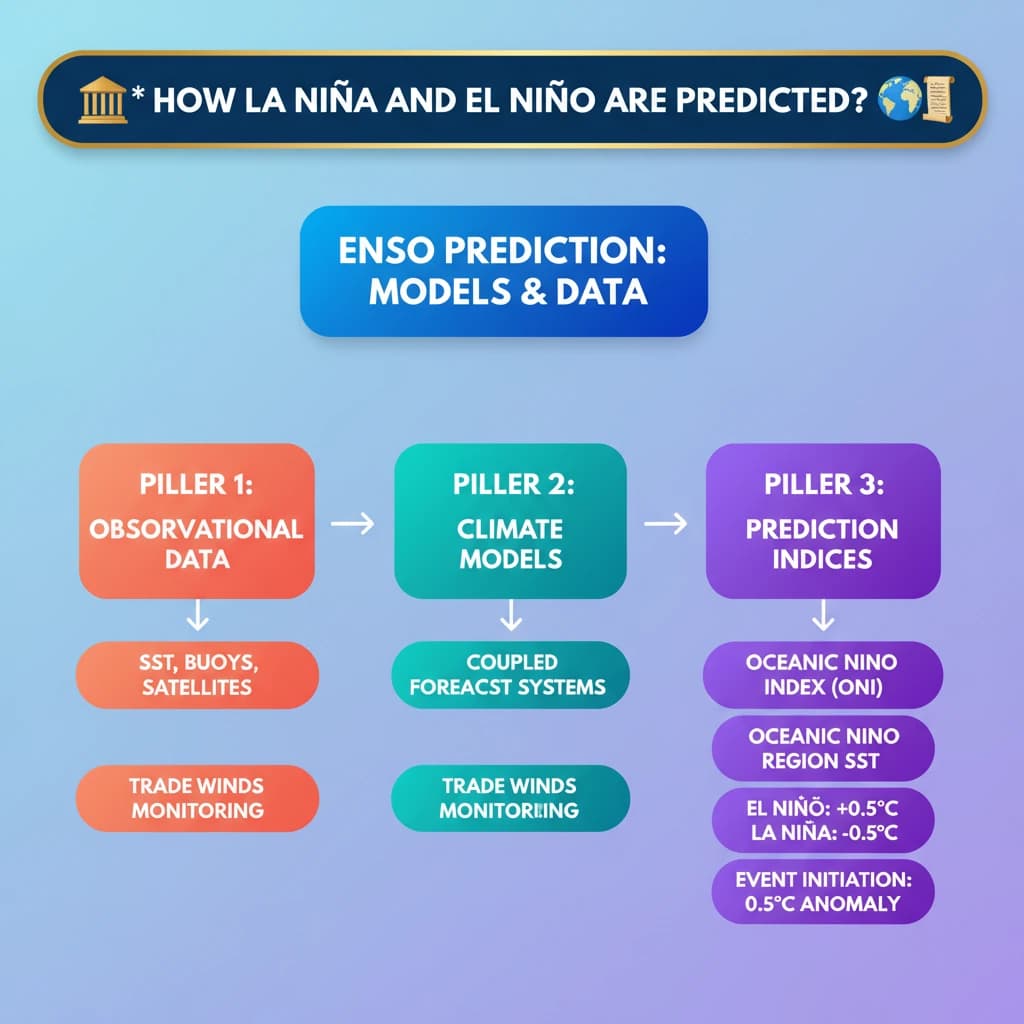
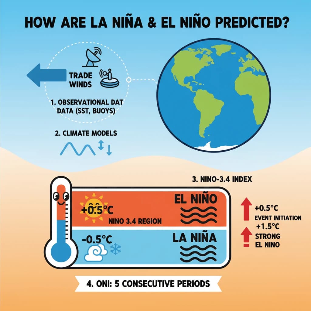
Key Observational Data
A variety of data sources are continuously monitored to track changes in oceanic and atmospheric conditions that signal an impending ENSO event.
- Sea Surface Temperatures (SSTs): Crucial for identifying warming (El Nino) or cooling (La Nina) anomalies in the equatorial Pacific.
- Trade Wind Strength: Changes in these winds are fundamental to the ENSO cycle, influencing ocean currents and temperature distribution.
- Satellite Data: Provides comprehensive, real-time coverage of ocean temperatures, sea levels, and wind patterns across vast areas.
- Ocean Buoys: A network of floating devices deployed across the Pacific, offering in-situ measurements of subsurface temperatures, currents, and atmospheric conditions.
Ocean buoys are instrumental floating devices placed in oceans for various purposes, including continuous environmental monitoring, critical data collection, and aiding navigation. They provide direct measurements that validate satellite observations.
The Oceanic Nino Index (ONI)
The Oceanic Nino Index (ONI) is the primary metric used by the U.S. National Oceanic and Atmospheric Administration (NOAA) to identify and classify El Nino and La Nina events.
It compares the 3-month running average of Sea Surface Temperatures (SSTs) in the East-Central Tropical Pacific (specifically the Nino 3.4 region) against a 30-year historical average for the same period.
ONI Thresholds:
- El Nino: Occurs when the difference between the 3-month average SST and the 30-year average is 0.5°C or higher for at least five consecutive overlapping 3-month periods.
- La Nina: Occurs when the difference is -0.5°C or lower for at least five consecutive overlapping 3-month periods.
The Nino-3.4 Index
The Nino-3.4 Index specifically refers to the average Sea Surface Temperature (SST) anomaly in the Nino 3.4 region of the equatorial Pacific (5°N-5°S, 120°-170°W).
This index is crucial for identifying the initiation and strength of ENSO events, providing a more granular look at the core region where these phenomena manifest.
Nino-3.4 Index Thresholds:
- An anomaly value of 0.5°C or greater typically indicates the initiation of an El Nino event.
- A stronger event, often associated with more significant global impacts, is indicated by a temperature anomaly of 1.5°C or more.
- Conversely, anomalies of -0.5°C or less signal the initiation of a La Nina event.
Lead Time for Predictions
The ability to predict ENSO events varies, with some events offering longer lead times than others due to their specific characteristics and preceding conditions.
Notably, La Nina events that follow a particularly strong El Nino can often be forecasted with a significant lead time, sometimes up to two years in advance.
Understanding the Oceanic Nino Index (ONI) and Nino-3.4 Index is vital for UPSC. These are not just definitions but tools to explain the 'how' of climate prediction, relevant for GS Paper 1 (Geography) and GS Paper 3 (Environment).
💡 Key Takeaways
- •ENSO prediction uses climate models and observational data (SST, trade winds, satellites, buoys).
- •Oceanic Nino Index (ONI) defines El Nino/La Nina based on 3-month average SST anomalies in East-Central Tropical Pacific (Nino 3.4 region).
- •ONI thresholds: +0.5°C for El Nino, -0.5°C for La Nina (for 5 consecutive periods).
- •Nino-3.4 Index identifies event initiation (0.5°C anomaly) and strength (1.5°C+ for strong El Nino).
- •La Nina following strong El Nino can be predicted up to two years in advance.
- •Accurate ENSO predictions are vital for agriculture, water management, and disaster preparedness globally.
🧠 Memory Techniques
98% Verified Content
📚 Reference Sources
•National Oceanic and Atmospheric Administration (NOAA) Climate Prediction Center
•World Meteorological Organization (WMO) ENSO Updates
•Indian Meteorological Department (IMD) Reports