Loading page, please wait…
Jamuna (called Brahmaputra in India) - UPSC Geography
What is Jamuna (called Brahmaputra in India) in UPSC Geography?
Jamuna (called Brahmaputra in India) is a key topic under Geography for UPSC Civil Services Examination. Key points include: Jamuna is a Brahmaputra distributary in Bangladesh, meeting Padma (Ganga) at Goalundo Ghat.. India-China share two major trans-border river systems: Brahmaputra (eastern) and Indus (western).. Brahmaputra is known as Yaluzangbu/Tsangpo in China and Siang in Arunachal Pradesh.. Understanding this topic is essential for both UPSC Prelims and Mains preparation.
Why is Jamuna (called Brahmaputra in India) important for UPSC exam?
Jamuna (called Brahmaputra in India) is a Medium-level topic in UPSC Geography. It is tested in both Prelims (factual MCQs) and Mains (analytical answer writing). Previous year UPSC questions have frequently covered aspects of Jamuna (called Brahmaputra in India), making it essential for comprehensive IAS preparation.
How to prepare Jamuna (called Brahmaputra in India) for UPSC?
To prepare Jamuna (called Brahmaputra in India) for UPSC: (1) Study the comprehensive notes covering all key concepts on Vaidra. (2) Practice previous year questions on this topic. (3) Connect it with current affairs using daily updates. (4) Revise using key takeaways and mind maps available for Geography. (5) Write practice answers linking Jamuna (called Brahmaputra in India) to related GS Paper topics.
Key takeaways of Jamuna (called Brahmaputra in India) for UPSC
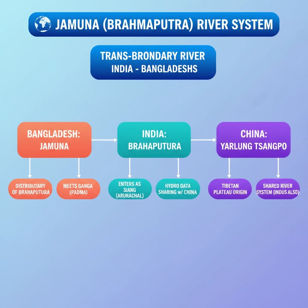
- Jamuna is a Brahmaputra distributary in Bangladesh, meeting Padma (Ganga) at Goalundo Ghat.
- India-China share two major trans-border river systems: Brahmaputra (eastern) and Indus (western).
- Brahmaputra is known as Yaluzangbu/Tsangpo in China and Siang in Arunachal Pradesh.
- India and China have MoUs for hydrological data sharing on Brahmaputra and Sutlej.
- Transboundary river management is crucial for regional water security and geopolitical stability.
Jamuna (called Brahmaputra in India)
Medium⏱️ 7 min read
geography
📖 Introduction
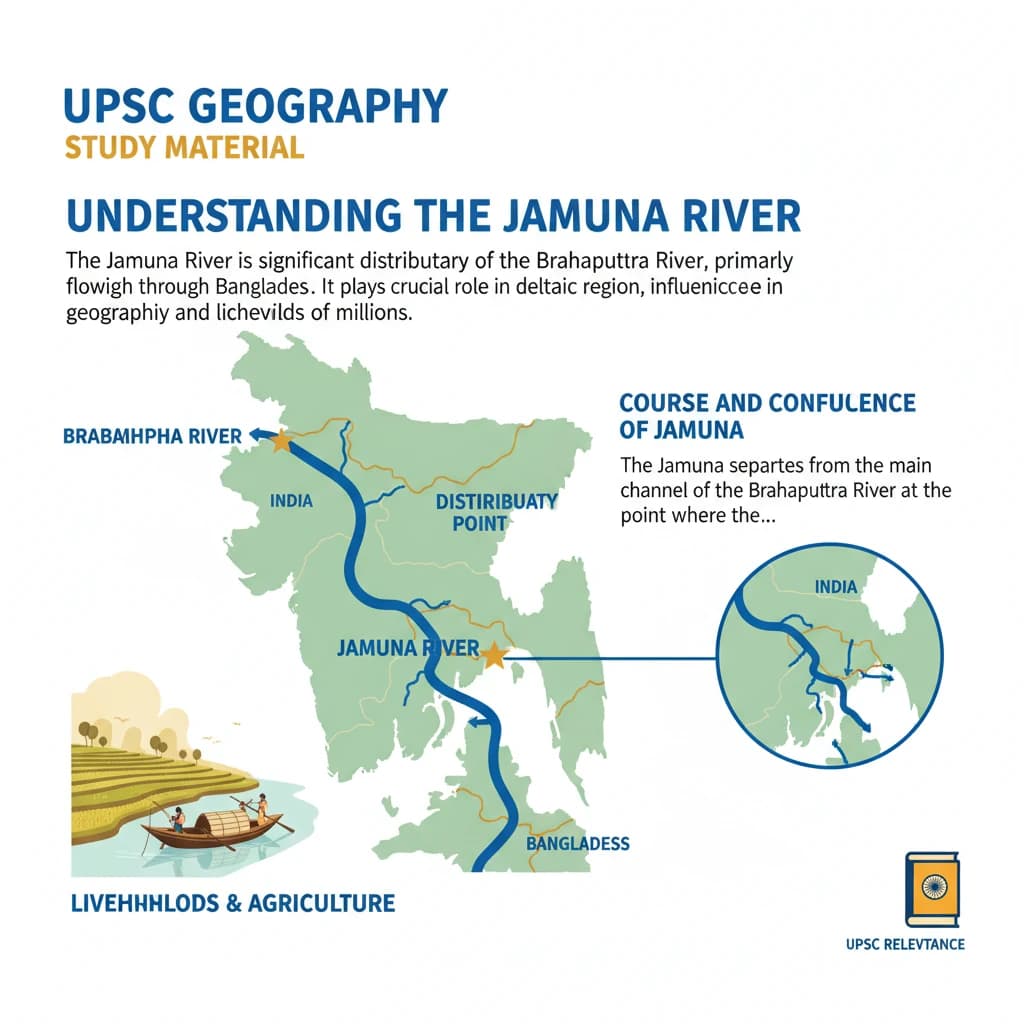
Understanding the Jamuna River
The Jamuna River is a significant distributary of the Brahmaputra River, primarily flowing through Bangladesh.
It plays a crucial role in the deltaic region, influencing the geography and livelihoods of millions.
Course and Confluence of Jamuna
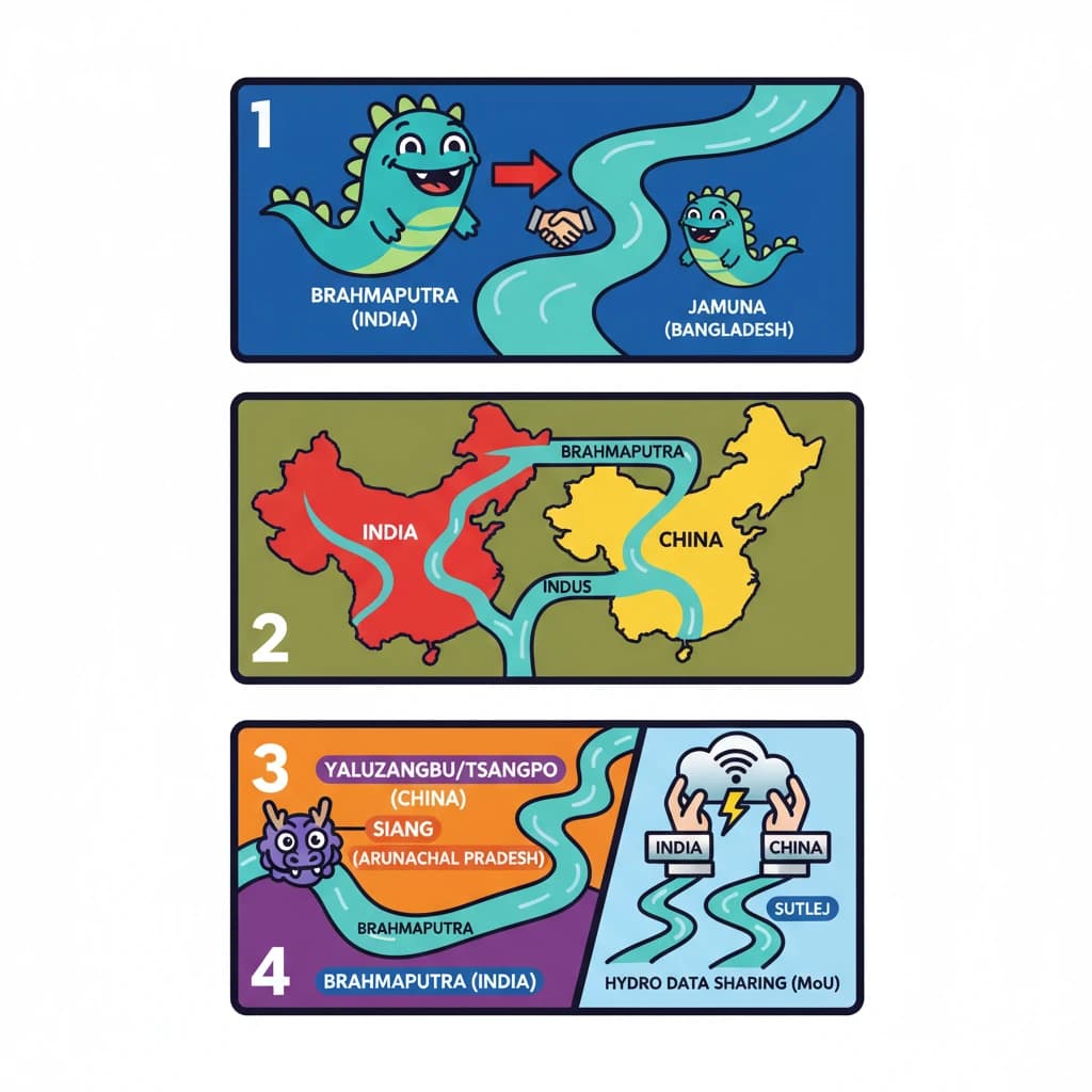
The Jamuna separates from the main channel of the Brahmaputra River at the point where the Brahmaputra converges with the Teesta River in Bangladesh.
It continues its journey under the name Jamuna until it reaches Goalundo Ghat, also in Bangladesh.
At Goalundo Ghat, the Jamuna River merges with the Padma River. The Padma River is known as the Ganga River in India before it enters Bangladesh.
Trans-border Rivers between India and China
Several major rivers flow across the international border from China into India, forming vital river systems for both nations.
These trans-border rivers are broadly categorized into two principal groups based on their geographical location and river basin.
Understanding these trans-border river systems is crucial for comprehending geopolitical and environmental dynamics in the region.
The Brahmaputra River System
Located on the eastern side of the India-China border, this system is a lifeline for northeastern India and Bangladesh.
- The main stream of the Brahmaputra River in India is known as Siang when it enters from China.
- Key tributaries include Subansiri and Lohit, which significantly contribute to its volume.
In China, the Brahmaputra River is known by its Tibetan names, primarily Yaluzangbu or Tsangpo.
The Indus River System
Situated on the western side of the India-China border, this system is vital for the arid regions of India and Pakistan.
- The primary rivers in this system, originating from China and flowing into India, are the Indus River itself and the Sutlej River.
Hydrological Information Sharing
To facilitate better water management and flood forecasting, India and China have established mechanisms for data exchange.
Two significant Memoranda of Understanding (MoUs) have been signed between India and China for the provision of hydrological information. These MoUs cover data sharing for both the Brahmaputra and Indus River Systems, particularly concerning upstream flow data from China to India.
💡 Key Takeaways
- •Jamuna is a Brahmaputra distributary in Bangladesh, meeting Padma (Ganga) at Goalundo Ghat.
- •India-China share two major trans-border river systems: Brahmaputra (eastern) and Indus (western).
- •Brahmaputra is known as Yaluzangbu/Tsangpo in China and Siang in Arunachal Pradesh.
- •India and China have MoUs for hydrological data sharing on Brahmaputra and Sutlej.
- •Transboundary river management is crucial for regional water security and geopolitical stability.
🧠 Memory Techniques
95% Verified Content