Loading page, please wait…
Lake-Effect Snow - UPSC Geography
What is Lake-Effect Snow in UPSC Geography?
Lake-Effect Snow is a key topic under Geography for UPSC Civil Services Examination. Key points include: Lake-effect snow is heavy, localized snowfall near large, warmer water bodies during cold periods.. It forms when cold air passes over warm lake water, picking up heat and moisture.. The warm, moist air rises, cools, condenses, and forms intense, narrow snow bands.. Understanding this topic is essential for both UPSC Prelims and Mains preparation.
Why is Lake-Effect Snow important for UPSC exam?
Lake-Effect Snow is a Medium-level topic in UPSC Geography. It is tested in both Prelims (factual MCQs) and Mains (analytical answer writing). Previous year UPSC questions have frequently covered aspects of Lake-Effect Snow, making it essential for comprehensive IAS preparation.
How to prepare Lake-Effect Snow for UPSC?
To prepare Lake-Effect Snow for UPSC: (1) Study the comprehensive notes covering all key concepts on Vaidra. (2) Practice previous year questions on this topic. (3) Connect it with current affairs using daily updates. (4) Revise using key takeaways and mind maps available for Geography. (5) Write practice answers linking Lake-Effect Snow to related GS Paper topics.
Key takeaways of Lake-Effect Snow for UPSC
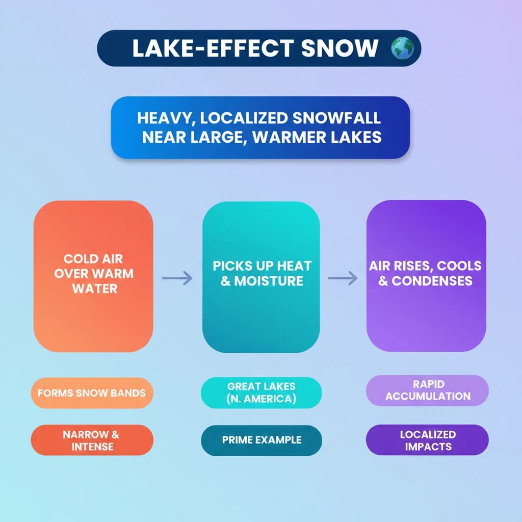
- Lake-effect snow is heavy, localized snowfall near large, warmer water bodies during cold periods.
- It forms when cold air passes over warm lake water, picking up heat and moisture.
- The warm, moist air rises, cools, condenses, and forms intense, narrow snow bands.
- The Great Lakes region of North America is a prime example of where it occurs.
- It leads to rapid snow accumulation and significant localized impacts on communities.

Lake-Effect Snow
Medium⏱️ 4 min read
geography
📖 Introduction
Introduction to Lake-Effect Snow
Recently, parts of upstate New York, Pennsylvania, Ohio, and Michigan experienced a significant weather event. These regions, situated along the Great Lakes of North America, witnessed what is known as “lake-effect snow.”
A particularly heavy snowstorm, caused by this phenomenon near Lake Erie in New York, transformed homes into ice-covered structures. This highlights the intense and localized nature of lake-effect snow events.
What is Lake-Effect Snow?
Definition: Lake-effect snow is a localized weather phenomenon characterized by heavy snowfall. It occurs near large bodies of water, most notably the Great Lakes in North America.
This phenomenon typically manifests during the colder months of the year. It happens when significantly cold air masses pass over the relatively warmer surfaces of large, unfrozen lakes.
The interaction between the cold air and warmer lake water results in the formation of intense and narrow bands of snowfall, often leading to rapid accumulation.
Mechanism of Lake-Effect Snow Formation
The formation of lake-effect snow involves a specific sequence of atmospheric processes. Understanding these steps is crucial for comprehending this unique weather pattern.
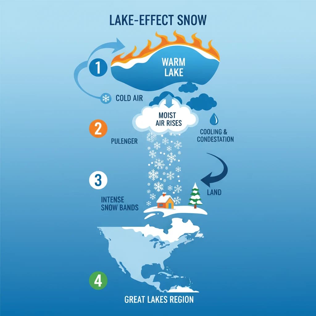
Cold Air Movement and Moisture Transfer
The process begins with the movement of cold air, frequently originating from Canada, flowing over the unfrozen, warmer waters of the Great Lakes in North America.
As this cold air passes over the lake, the warmer lake surface transfers both heat and moisture into the overlying colder air. This transfer occurs primarily at the surface of the lake.
Cloud Formation
The newly warmed and moistened air, being less dense, begins to rise rapidly into the colder atmosphere above. As it ascends, it cools quickly due to expansion and interaction with the colder upper air.
This rapid cooling causes the water vapor within the air to condense, leading to the formation of clouds. These clouds are typically organized into distinct, narrow bands parallel to the wind direction.
Intense Snowfall
These developing cloud bands are highly efficient at producing precipitation. They generate intense snowfall, which can accumulate very quickly on land downwind of the lakes.
Snowfall Rates: Lake-effect snow often produces high snowfall rates, frequently exceeding 2–3 inches (5-7.5 cm) or more per hour, leading to significant accumulations in a short period.
For UPSC Geography (Paper I), understanding the conditions (cold air, warm lake, fetch, instability) and the process of lake-effect snow is important. It can be asked in questions related to climatology, atmospheric phenomena, or regional geography of North America.
💡 Key Takeaways
- •Lake-effect snow is heavy, localized snowfall near large, warmer water bodies during cold periods.
- •It forms when cold air passes over warm lake water, picking up heat and moisture.
- •The warm, moist air rises, cools, condenses, and forms intense, narrow snow bands.
- •The Great Lakes region of North America is a prime example of where it occurs.
- •It leads to rapid snow accumulation and significant localized impacts on communities.
🧠 Memory Techniques
98% Verified Content
📚 Reference Sources
•General Meteorological and Geographical Knowledge