Loading page, please wait…
Types of landslides - UPSC Geography
What is Types of landslides in UPSC Geography?
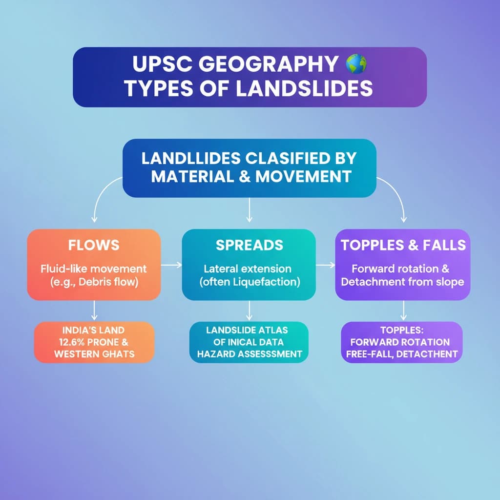
Types of landslides is a key topic under Geography for UPSC Civil Services Examination. Key points include: Landslides are classified into Flows, Spreads, Topples, and Falls based on material and movement.. Flows involve fluid-like movement (e.g., debris flows); Spreads are lateral extensions often due to liquefaction.. Topples are forward rotations and free-falls; Falls are detachments from steep slopes.. Understanding this topic is essential for both UPSC Prelims and Mains preparation.
Why is Types of landslides important for UPSC exam?
Types of landslides is a Medium-level topic in UPSC Geography. It is tested in both Prelims (factual MCQs) and Mains (analytical answer writing). Previous year UPSC questions have frequently covered aspects of Types of landslides, making it essential for comprehensive IAS preparation.
How to prepare Types of landslides for UPSC?
To prepare Types of landslides for UPSC: (1) Study the comprehensive notes covering all key concepts on Vaidra. (2) Practice previous year questions on this topic. (3) Connect it with current affairs using daily updates. (4) Revise using key takeaways and mind maps available for Geography. (5) Write practice answers linking Types of landslides to related GS Paper topics.
Key takeaways of Types of landslides for UPSC
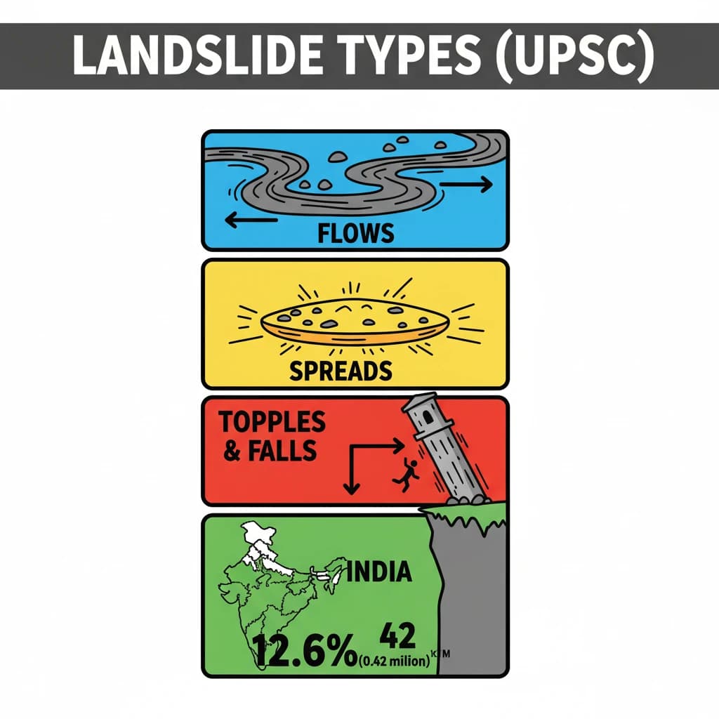
- Landslides are classified into Flows, Spreads, Topples, and Falls based on material and movement.
- Flows involve fluid-like movement (e.g., debris flows); Spreads are lateral extensions often due to liquefaction.
- Topples are forward rotations and free-falls; Falls are detachments from steep slopes.
- Approximately 12.6% (0.42 million sq. km) of India's land area is landslide-prone, concentrated in the Himalayas and Western Ghats.
- The Landslide Atlas of India provides critical data for hazard assessment.
- Understanding landslide types is crucial for effective disaster management and mitigation strategies.
Types of landslides
Medium⏱️ 8 min read
geography
📖 Introduction
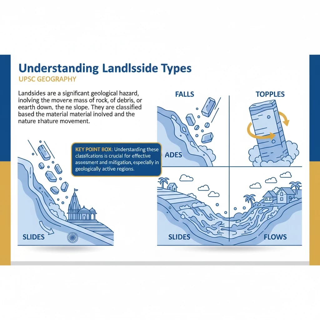
Understanding Landslide Types
Landslides are a significant geological hazard, involving the movement of a mass of rock, debris, or earth down a slope. They are broadly classified based on the type of material involved and the nature of movement.
Understanding these classifications is crucial for effective hazard assessment and mitigation strategies, especially in geologically active regions.
Flows
Flows describe landslides where soil or rock material mixes with water, moving downslope like a viscous fluid. This category encompasses several distinct phenomena.
- Earth Flows: Slow to rapid movement of fine-grained soil.
- Debris Flows: Rapid movement of a mixture of water, soil, and rock fragments.
- Mudflows: Very rapid flow of water-saturated fine-grained material.
- Creep: Extremely slow, imperceptible downslope movement of soil and rock, often influenced by freeze-thaw cycles.
Spreads
Spreads involve the lateral extension and cracking of a ground mass. This type of movement often occurs on gentle slopes or flat terrain due to the liquefaction of underlying saturated granular materials like sand.
Liquefaction is a phenomenon where saturated, loose granular soil temporarily loses strength and stiffness, behaving like a liquid due to applied stress, typically from an earthquake or rapid loading.
Topples
Topples are characterized by the forward rotation and free-fall of a mass of rock or earth from a vertical or near-vertical slope. This typically happens when the center of gravity of a block of material moves beyond its base of support.
Toppling failures are common in areas with steeply dipping rock strata or heavily jointed rock masses, leading to sudden and dangerous collapses.
Falls
Falls involve the detachment of rock or earth material from a steep slope or cliff face. The detached material then descends primarily by free-fall, but can also involve bouncing or rolling down the slope.
Rockfalls are a common example of falls, frequently triggered by weathering, earthquakes, or heavy rainfall, especially in mountainous regions.
Landslide Prone Areas in India
India, with its diverse geological and topographical features, has significant areas vulnerable to landslides. The Landslide Atlas of India provides crucial data on these susceptible regions.
According to the Landslide Atlas of India, approximately 0.42 million sq. km, which constitutes about 12.6% of the country's total land area, is prone to landslides.
The distribution of these prone areas highlights specific geological and climatic vulnerabilities across different regions:
- North East Himalaya: Approximately 0.18 million sq. km.
- North West Himalaya: Approximately 0.14 million sq. km.
- Western Ghats and Konkan Hills: Approximately 0.09 million sq. km.
- Eastern Ghats of Andhra Pradesh: Approximately 0.01 million sq. km.
Knowledge of these landslide-prone regions is vital for UPSC Mains answers, particularly in Geography (GS Paper I) and Disaster Management (GS Paper III). Be prepared to discuss their causes and mitigation strategies.
💡 Key Takeaways
- •Landslides are classified into Flows, Spreads, Topples, and Falls based on material and movement.
- •Flows involve fluid-like movement (e.g., debris flows); Spreads are lateral extensions often due to liquefaction.
- •Topples are forward rotations and free-falls; Falls are detachments from steep slopes.
- •Approximately 12.6% (0.42 million sq. km) of India's land area is landslide-prone, concentrated in the Himalayas and Western Ghats.
- •The Landslide Atlas of India provides critical data for hazard assessment.
- •Understanding landslide types is crucial for effective disaster management and mitigation strategies.
🧠 Memory Techniques
95% Verified Content
📚 Reference Sources
•Geological Survey of India (GSI) reports on landslides
•National Disaster Management Authority (NDMA) guidelines
•ISRO's Landslide Atlas of India