Loading page, please wait…
Vaidra Logo
Vaidra

Top 4 items + smart groups

UPSC GPT
New
Current Affairs
Daily Solutions
Daily Puzzle
Mains Evaluator

Version 2.0.0 • Built with ❤️ for UPSC aspirants

Loading...
Loading...
Loading...
Loading...
Loading...
Loading...
Loading...
Loading...
Loading...
Loading...
Loading...
Loading...
Loading...
Back
All Subjects

Topics

0 topics • 0 completed

Loading topics...
Loading...
Loading...
Loading...
Loading...
Loading...
Overall Progress0%

What is the Line of Actual Control (LAC)? - UPSC International Relations

What is What is the Line of Actual Control (LAC)? in UPSC International Relations?

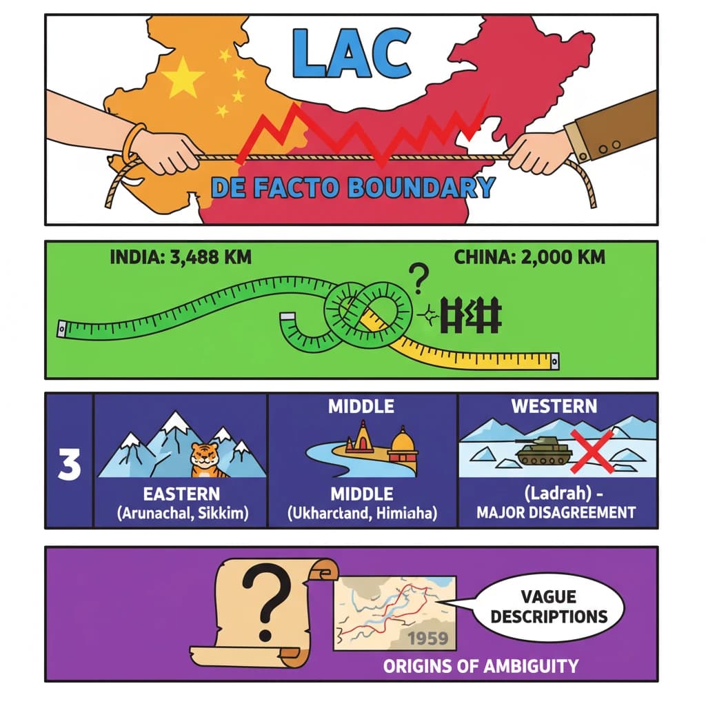
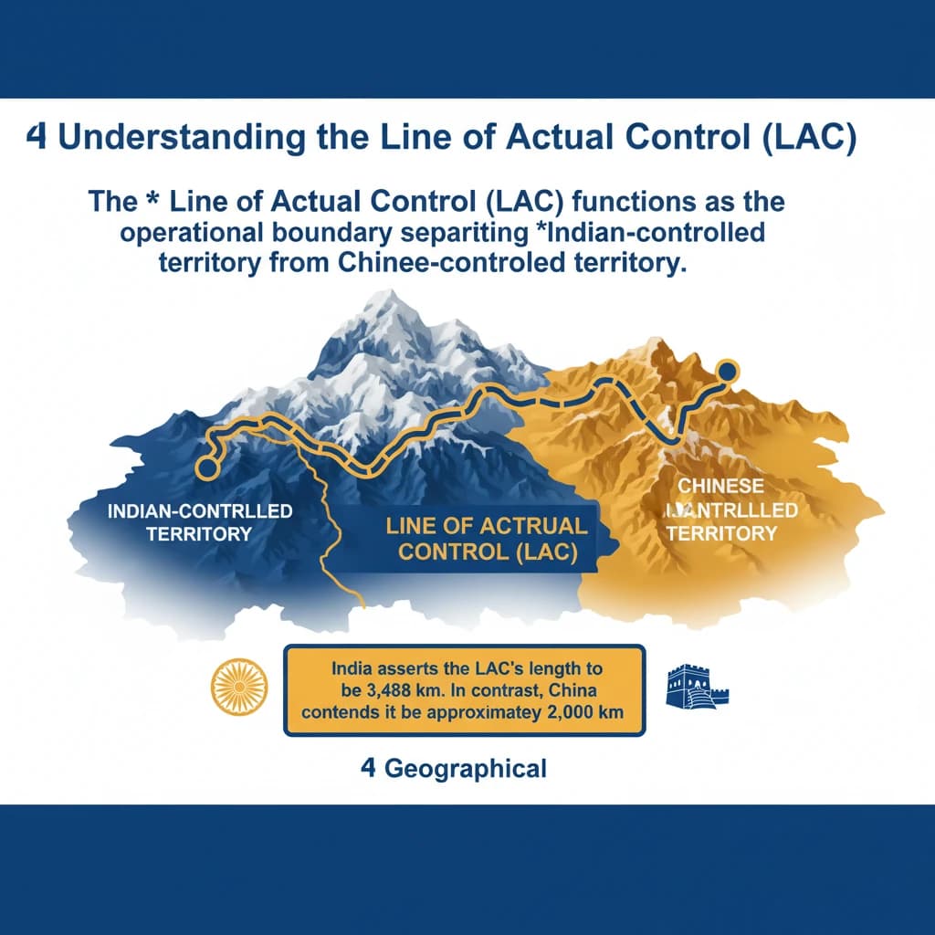
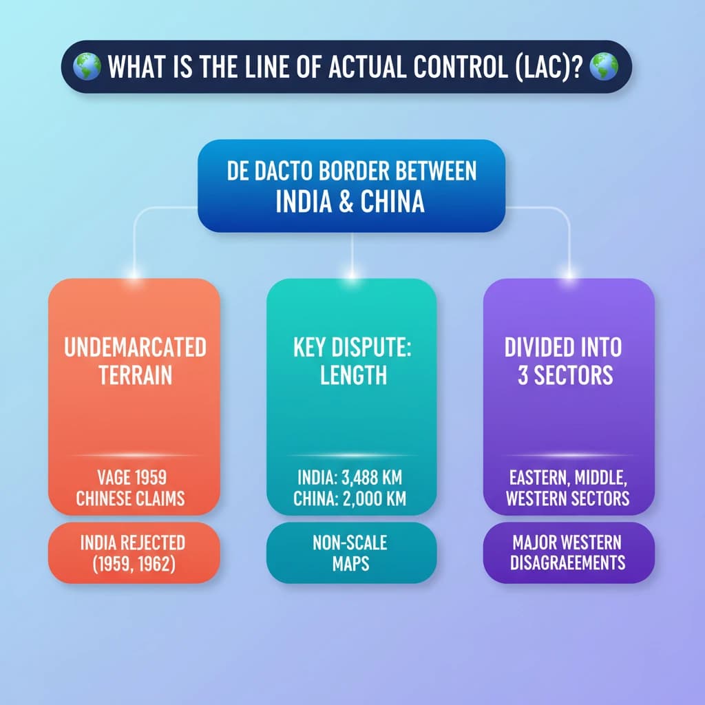
What is the Line of Actual Control (LAC)? is a key topic under International Relations for UPSC Civil Services Examination. Key points include: The LAC is the de facto boundary separating Indian and Chinese controlled territories.. India claims LAC is 3,488 km, China claims 2,000 km, highlighting a key dispute.. It is divided into three sectors: Eastern (Arunachal, Sikkim), Middle (Uttarakhand, Himachal), and Western (Ladakh), with major disagreements in the Western sector.. Understanding this topic is essential for both UPSC Prelims and Mains preparation.

Why is What is the Line of Actual Control (LAC)? important for UPSC exam?

What is the Line of Actual Control (LAC)? is a Medium-level topic in UPSC International Relations. It is tested in both Prelims (factual MCQs) and Mains (analytical answer writing). Previous year UPSC questions have frequently covered aspects of What is the Line of Actual Control (LAC)?, making it essential for comprehensive IAS preparation.

How to prepare What is the Line of Actual Control (LAC)? for UPSC?

To prepare What is the Line of Actual Control (LAC)? for UPSC: (1) Study the comprehensive notes covering all key concepts on Vaidra. (2) Practice previous year questions on this topic. (3) Connect it with current affairs using daily updates. (4) Revise using key takeaways and mind maps available for International Relations. (5) Write practice answers linking What is the Line of Actual Control (LAC)? to related GS Paper topics.

Key takeaways of What is the Line of Actual Control (LAC)? for UPSC

  • The LAC is the de facto boundary separating Indian and Chinese controlled territories.
  • India claims LAC is 3,488 km, China claims 2,000 km, highlighting a key dispute.
  • It is divided into three sectors: Eastern (Arunachal, Sikkim), Middle (Uttarakhand, Himachal), and Western (Ladakh), with major disagreements in the Western sector.
  • The LAC's ambiguity originates from vague Chinese descriptions in 1959, using non-scale maps.
  • India initially rejected the LAC (1959, 1962) due to its undefined nature, but shifted its approach in the mid-1980s for pragmatic border management.
  • Incidents like Doklam (2017) and Galwan (2020) exemplify the persistent tensions and differing perceptions along the LAC.
What is the Line of Actual Control (LAC)?

What is the Line of Actual Control (LAC)?

Medium⏱️ 7 min read✓ 95% Verified
international relations

📖 Introduction

<h4>Understanding the Line of Actual Control (LAC)</h4><p>The <strong>Line of Actual Control (LAC)</strong> functions as the operational boundary separating <strong>Indian-controlled territory</strong> from <strong>Chinese-controlled territory</strong>.</p><div class="info-box"><p><strong>India</strong> asserts the <strong>LAC's length</strong> to be <strong>3,488 km</strong>. In contrast, <strong>China</strong> contends it to be approximately <strong>2,000 km</strong>.</p></div><h4>Geographical Demarcation of the LAC</h4><p>This demarcation is traditionally categorized into <strong>three distinct sectors</strong>, each with its unique geographical and historical context.</p><ul><li><strong>Eastern sector</strong>: Encompasses the regions of <strong>Arunachal Pradesh</strong> and <strong>Sikkim</strong>.</li><li><strong>Middle sector</strong>: Spans across <strong>Uttarakhand</strong> and <strong>Himachal Pradesh</strong>.</li><li><strong>Western sector</strong>: Primarily located in the strategically crucial region of <strong>Ladakh</strong>.</li></ul><h4>Core Disagreements Regarding the LAC</h4><p>The fundamental dispute surrounding the <strong>LAC</strong> stems from differing perceptions of its <strong>precise alignment</strong> across these various sectors.</p><p>In the <strong>eastern sector</strong>, the <strong>LAC</strong> generally follows the historically significant <strong>1914 McMahon Line</strong>, with only minor disagreements concerning specific ground positions.</p><p>However, <strong>major disagreements</strong> are concentrated in the <strong>Western sector</strong>. These disputes trace their origins back to letters exchanged between <strong>Chinese Prime Minister Zhou Enlai</strong> and <strong>Indian Prime Minister Jawahar Nehru</strong> in <strong>1959</strong>.</p><div class="key-point-box"><p>The <strong>Chinese</strong> initially described the <strong>LAC</strong> only in <strong>general terms</strong> on maps that were <strong>not to scale</strong>, contributing significantly to its inherent ambiguity.</p></div><p>Following the <strong>1962 War</strong>, <strong>China</strong> claimed to have withdrawn its forces <strong>20 km behind the LAC</strong> in <strong>November 1959</strong>, a claim that further complicated the understanding of its actual position.</p><p>During the <strong>Doklam crisis</strong> in <strong>2017</strong>, the <strong>Chinese Foreign Ministry spokesperson</strong> urged <strong>India</strong> to abide by the <strong>“1959 LAC”</strong>, further highlighting the persistent ambiguity.</p><p>Despite subsequent clarifications, this ambiguity has persisted, leading to <strong>contrasting interpretations</strong> by both nations regarding the LAC's true alignment.</p><h4>India's Evolving Stance on the LAC</h4><p>Initially, <strong>India rejected</strong> the concept of the <strong>LAC</strong> in both <strong>1959</strong> and <strong>1962</strong>.</p><p>This rejection was primarily due to concerns over its <strong>vague definition</strong> and the potential for <strong>China</strong> to exploit this ambiguity to alter <strong>ground realities</strong> through military force.</p><p>A significant shift in <strong>India's approach</strong> to the <strong>LAC</strong> began in the <strong>mid-1980s</strong>. This change was prompted by an increase in <strong>border encounters</strong>, necessitating a review of patrolling boundaries and a more pragmatic engagement with the concept.</p><div class="exam-tip-box"><p>Understanding the historical evolution of <strong>India's stance</strong> on the <strong>LAC</strong> is crucial for analyzing current <strong>India-China relations</strong> in <strong>UPSC Mains GS-2 (International Relations)</strong>.</p></div>
Concept Diagram

💡 Key Takeaways

  • •The LAC is the de facto boundary separating Indian and Chinese controlled territories.
  • •India claims LAC is 3,488 km, China claims 2,000 km, highlighting a key dispute.
  • •It is divided into three sectors: Eastern (Arunachal, Sikkim), Middle (Uttarakhand, Himachal), and Western (Ladakh), with major disagreements in the Western sector.
  • •The LAC's ambiguity originates from vague Chinese descriptions in 1959, using non-scale maps.
  • •India initially rejected the LAC (1959, 1962) due to its undefined nature, but shifted its approach in the mid-1980s for pragmatic border management.
  • •Incidents like Doklam (2017) and Galwan (2020) exemplify the persistent tensions and differing perceptions along the LAC.

🧠 Memory Techniques

Memory Aid
95% Verified Content

📚 Reference Sources

•General knowledge on India-China border disputes

Related Topics

Loading related topics...
Explore:International Relations Topics·All Subjects·Daily Current Affairs·Editorial Analysis·Previous Year Questions·UPSC GPT
What is the Line of Actual Control (LAC)? - UPSC International Relations