ISRO Study Links Glacier Ice‑Patch Collapse to 2025 Dharali Flash Flood – Implications for Cryospheric Hazard Monitoring
Scientists from the <span class="key-term" data-definition="Indian Space Research Organisation — India's national space agency responsible for space research and satellite missions (GS3: Science & Technology)">ISRO</span> studied the August 5 2025 flash flood in Dharali, Uttarakhand, linking it to the collapse of an exposed ice‑patch on the <span class="key-term" data-definition="Srikanta Glacier — a valley glacier in the upper Bhagirathi basin whose deglaciation triggered the flood (GS3: Environment)">Srikanta Glacier</span>. The research highlights how <span class="key-term" data-definition="Deglaciation — the process of glacier retreat and loss of ice mass due to warming, a key indicator of climate change (GS3: Environment)">deglaciation</span> and <span class="key-term" data-definition="Nivation — erosion and hollow formation beneath snowbanks caused by repeated freeze‑thaw cycles, creating zones vulnerable to ice‑patch collapse (GS3: Environment)">nivation</span> expose ice patches that can rapidly fail, underscoring the need for systematic <span class="key-term" data-definition="Satellite observations — remote sensing data captured from space, used for monitoring terrain, glaciers, and early warning of disasters (GS3: Science & Technology)">satellite monitoring</span> as an early‑warning tool for Himalayan cryospheric hazards.
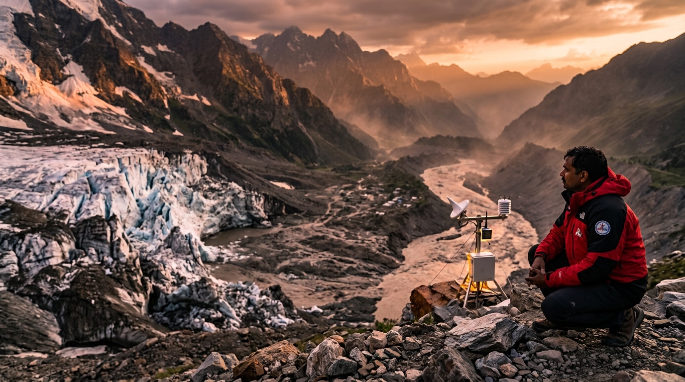
Overview A recent ISRO study, published in *NPJ Natural Hazards*, analyses the flash flood that struck Dharali village, Uttarakhand on 5 August 2025 . The flood, which claimed six lives, was triggered by the sudden collapse of an exposed ice‑patch on the Srikanta Glacier . The research underscores how warming‑induced deglaciation creates new hazards beyond the well‑known glacial lake outburst floods ( GLOF ). Key Developments Pre‑event satellite observations identified exposed ice patches on north‑facing slopes of the glacier during the ablation season. The exposed ice patch collapsed, releasing ice, meltwater, and debris, which surged down the Khir Gad stream, breaching the village. The study expands recognised Himalayan glacier hazards to include cryospheric instabilities such as ice‑patch failures. Historical context: the region previously suffered massive landslides during the June 2013 floods, indicating a pattern of climate‑linked geomorphic hazards. Important Facts The research area spans the ridge‑to‑valley system from the Srikanta Glacier (elevation 6,133 m) to Dharali (2,650‑2,700 m). The glacier features steep accumulation and ablation zones, extensive nivation hollows, and a history of unstable ice surfaces reported by mountaineers. The flash flood was amplified because the Khir Gad stream bifurcates the village, exposing both banks to sudden water surges. UPSC Relevance Understanding these emerging hazards is vital for multiple GS papers: GS 3 (Environment & Climate Change) : Links between deglaciation , cryospheric processes, and disaster risk. GS 4 (Disaster Management) : Need for early‑warning systems, remote sensing integration, and community‑level preparedness in high‑altitude zones. GS 5 (Science & Technology) : Role of space‑based monitoring in climate adaptation and hazard mitigation. Way Forward Policy makers and disaster‑risk agencies should: Incorporate systematic monitoring of nivation hollows and exposed ice patches across the Himalaya using high‑resolution satellite observations . Expand hazard‑assessment frameworks beyond GLOF scenarios to include ice‑patch collapse and related cryo‑hydrological events. Develop community‑based early‑warning protocols that integrate real‑time remote‑sensing alerts with local communication networks. Promote interdisciplinary research linking glaciology, climatology, and disaster management to refine predictive models. By recognising exposed ice patches as precursors of flash floods, India can enhance its climate‑resilient infrastructure and safeguard vulnerable mountain communities.
Quick Reference
Key Insight
Ice‑patch collapse on Srikanta Glacier triggers 2025 Dharali flood, urging satellite‑based cryo‑hazard monitoring
Key Facts
- The flash flood hit Dharali village, Uttarakhand on 5 August 2025, killing six people.
- It was caused by the sudden collapse of an exposed ice‑patch on the Srikanta Glacier (elevation 6,133 m).
- Pre‑event high‑resolution satellite imagery detected the ice‑patch on north‑facing slopes during the ablation season.
- The study, authored by ISRO scientists, was published in *NPJ Natural Hazards* and highlights ice‑patch failure as a distinct Himalayan hazard beyond GLOFs.
- The glacier‑valley system spans 6,133 m to 2,650‑2,700 m, featuring extensive nivation hollows that predispose ice‑patch instability.
- The research recommends systematic satellite monitoring of nivation hollows and community‑based early‑warning protocols.
Background
Deglaciation driven by climate warming is creating novel cryospheric hazards in the Himalayas, expanding the disaster‑risk profile beyond traditional glacial lake outburst floods. Integrating space‑based remote sensing with local preparedness aligns with GS‑3 (environment) and GS‑4 (disaster management) imperatives for climate‑resilient development.
UPSC Syllabus
- Prelims_GS — Science and Technology Applications
- Essay — Environment and Sustainability
- Essay — Science, Technology and Society
- GS1 — Important Geophysical Phenomena
Mains Angle
In GS‑3 or GS‑4, candidates can discuss how satellite‑enabled monitoring of ice‑patch collapse can be institutionalised within India’s disaster‑risk management framework, emphasizing policy reforms and inter‑agency coordination.